The Wawona Road...
Camp And Hike Along The Historic Yosemite Stage Route


Travel The Old Yosemite Stage Route
The Wawona Road…Highway 41, is also known by other names including State Route 41, and the Southern Yosemite Highway.
California Highway 41 intersects State Highway 1 at its southernmost
point at Morro Bay. It then runs roughly 185 miles northeasterly through
the Coastal Range on its way toward Yosemite, passing through Fresno
and Atascadero along the way. Before entering the Sierra Nevada mountain
range, the Wawona Road runs through the towns of Coarsegold and
Oakhurst.
Oakhurst…once known as Fresno Flats is 14 miles (23 km) south of the entrance to Yosemite National Park in the Sierra Nevada foothills.
Highlights Along The Wawona Road
Yosemite’s Wawona Road offers a scenic drive with plenty of things to do along the way...These include:
Wawona and the Yosemite Pioneer History Center
The historical community of Wawona has a long and interesting history…Not far from the old Wawona Hotel is the Yosemite Pioneer History Center which is the location of the most historically significant structures from around Yosemite National Park, and includes the famous Wawona Covered Bridge .
The complete story of the Yosemite Pioneer History Center may be enjoyed at Yosemite Pioneer History Center.
Also in Wawona, there are a number of hiking trails from near the Wawona Road into the backcountry…or take the easier nearby hikes with the whole family.
The National Park Service provides the following information to help you plan your trip...
The Wawona Campground:
The Wawona campground is located one mile north of Wawona, on the Wawona Road and is open all year long.
Reservations are required for those camping during the busy months of April through September and may be made at this NPS website... Wawona Campground Reservations.
From October through March, campsites are available on a first-come, first-served basis.
Horse site reservations are always required and are available by calling 877-444-6777.
Cost To Camp
The cost is $20/night for each campsite, with a maximum of 6 people per site...$14 per night from October through April. $40/night for the group campsite (13-30 people per site).
Camping Details:
- Sites Available: 93...plus one group site and two horse sites.
- Maximum Trailer length: up to 35 ft...no trailers in group sites; 27 ft trailer limit in the horse sites.
- Location of Dump Station: Nearby, on Forest Drive east of Wawona ...summer only.
- Food and Supplies: Nearby...small grocery store in Wawona.
- Showers: Yosemite Valley in Curry Village and Housekeeping Camp.
- Pet Policy: Permitted...except in group and horse sites.
Yosemite Pet Regulations Link: Yosemite Pet Regulations
Wawona Campground Details:
- All campsites contain a fire ring, picnic table, and food locker [33"(D)x45"(W)x18"(H)].
- Bathrooms are nearby with potable water and flushing toilets.
The group site contains six food lockers. - Campsites 69 and 70 are suitable for wheelchairs. Picnic tables at these sites have extended tops. Camps 69 and 70 are expressly reserved for people with disabilities.
Wawona
The community of Wawona was established as a natural stopping point for the early stagecoaches on their long trek to Yosemite. The industrious Washburn brothers built the Wawona Hotel to provide an overnight stop for this purpose, and it serves guests at its original location to this day.
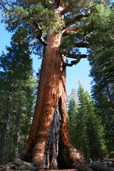
A drive along the Wawona Road stage route provides a picturesque first introduction to Yosemite’s old growth forests. The nearby Mariposa Grove of Sequoia Trees is something that should not be missed.
Forest Fires

It is the policy of the National Park Service to allow naturally occurring forest fires to burn. In the process thick underbrush is destroyed and opens the forest floor to new growth, and it is an interesting fact that Giant Sequoia cones require the heat from fire to open and drop their seeds.
You may still see signs of old forest fires along the Wawona Road that started from lightning strikes back in 1990…those fires burned more than 8,000 acres.
The Wawona Tunnel And Tunnel View
When the Wawona Road into Yosemite Valley was put into service by the Washburn brothers, it was established as a toll road. The early road passed over the lip of the valley and followed steep and dangerous switch-backs down the side of the cliff to the bottom.
Many years later on June 10th, 1933 a major improvement was completed.
After twenty nine months of blasting through over 4,200 feet of granite,
the Wawona Tunnel opened.
The Wawona Road was shortened and
redirected through the new tunnel…exiting at “Tunnel View” about a mile
and a half up the road from the valley floor.
Tunnel View now
provides many new visitors to the park with their first glimpse of
Yosemite Valley. It is one of the most photographed vistas in Yosemite
providing views of Yosemite Valley, El Capitan, Half Dome, and
Bridalveil Falls from a single vantage point.

National Park Service Guides For Day Hikes in Wawona and the Mariposa Grove...
Download a printable [2MB PDF] National Park Service generated hiking brochure with map of Wawona and the Mariposa Grove here:
Wawona and Mariposa Grove Day Hikes brochure download.
Wawona Meadow Loop:
An easy 3.5 miles (5.6 km) loop; 2 hours [leashed pets allowed]
Begin at the Wawona Hotel...Walk across the Wawona golf course on the paved road. Once across the golf course, take the first left onto the unpaved fire road that loops around the meadow.
Read more about wildflowers in this meadow at...Wawona wildflower walks.
Swinging Bridge Loop:
An easy 4.8 miles (7.6 km) loop; about 2 hours to complete
Begin at the Wawona Store parking area...Follow Forest Drive, the paved road, two miles upstream from the store to the Seventh Day Adventist camp.
At the camp, bear to the left onto a dirt road and continue a half-mile to Swinging Bridge. Cross the bridge and bear left onto the trail that becomes a dirt road, then paved Chilnualna Falls Road.
This road will take you back to the Pioneer Yosemite History Center. Walk through the history center and its covered bridge to return to the Wawona Store.
Download a self-guiding trail brochure for the Pioneer Yosemite History Center here: Yosemite Pioneer History Center Brochure Download
Wawona to Mariposa Grove:
A moderate 6 miles (9.6 km) to the Grizzly Giant tree in the Mariposa Grove.
Begin at Wawona Hotel...The trail begins behind the last uphill building of the Wawona Hotel at the Moore Cottage. Look for the trailhead 50 yards uphill marked by the sign "Two Hour Trail Ride."
(You can return on the free Wawona-Mariposa Grove shuttle bus back to Wawona...See complete information at):Wawona and Mariposa Grove Shuttle.
Mariposa Grove of Giant Sequoias:
Moderate Hikes to...Grizzly Giant: 1.6 miles (2.5 km) round-trip...1 hour
Wawona Point: 6 miles (9.6 km) round-trip...3 hours
Outer Loop Trail: 6.9 miles (11 km) loop...4 to 5 hours.
Trails From The Mariposa Grove

Various trails crisscross at the Mariposa Grove:
To reach the Grizzly Giant or Wawona Point, follow the trail that begins at the far end of the parking area.
Hike beyond the Grizzly Giant and California Tunnel Tree toward the Galen Clark Tree to reach the Upper Grove and Wawona Point. The Outer Loop Trail begins on the uphill side of the parking area.
Download a self-guiding hiking brochure and map for the Mariposa Grove...Mariposa Grove Brochure Download
Alder Creek:
A strenuous 12 miles (18.7 km)...6 to 8 hours.
Begin 0.4 miles up Chilnualna Falls Road...
The trail begins across the street from the parking area at the "Backcountry Use" sign and leads uphill north through an open pine forest with abundant manzanita growing on its drier slopes.
Chilnualna Falls:
A strenuous 8.2 miles (13.1 km) round-trip...5 hours and a 2,400 feet elevation gain.
Begin at Chilnualna Falls parking area, two miles up the Chilnualna Falls Road...
The trail leads from the bottom of the parking area and along cascading Chilnualna Creek for a half mile (0.8 km). A series of switchbacks then lead away from the creek into the open forest, with great views of the Wawona area.
To return to the home page from Wawona Road please click here.

 Subscribe To Our Blog Here


Yosemite's Wawona
Bill Berry's Prints Return

Don't Miss The Big Trees
Be Sure To See The Big Trees While In Wawona
Wawona...The Washburn Brothers And The Wawona Hotel

Yosemite Stage- Drivers Stories... A Book And Kindle eBook

Yosemites Stories Of The Stagedrivers
Yosemite's Pioneer History Center In Wawona

Yosemite Pioneer History Center
Yosemite's Painter Thomas Hill

Yosemite's Painter Thomas Hill
Yosemite's Half Dome The First Climb

Yosemites Half Dome The First Climb
Yosemite's Covered Bridge...The Story

Saving Yosemites Historic Covered Bridge